
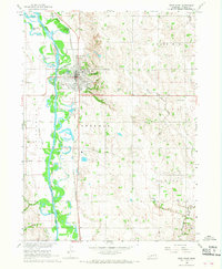
1966 Map of Snyder
USGS Topo · Published 1967About this map
Snyder and the eastern edge of Dodge anchor this mid-1960s survey of the Nebraska plains, where the landscape is organized into the townships of Monterey, St Charles, Webster, Pebble, Pleasant Valley, and Ridgeley. The agricultural character of the region is punctuated by cultural landmarks that reflect its settlement history, including the St Wenceslaus Cem and the Bohemian Ch near the Cuming Co Dodge Co boundary. One notable transition in the local infrastructure is the presence of an Old Railroad Grade winding through the valley of Pebble Creek, indicating a shift in the transportation network that once supported these rural communities. Small-scale details like School No 29 and the Glencoe Ch provide specific points of interest for genealogists tracing family roots in this corner of the Missouri River Basin.
Find a feature on this map
20 named features on this map. Tap any name to fly to it.
Don’t see what you’re looking for? This feature index may not catch every label — zoom into the map to look around manually.
Map Details
Editions of this 1966 Snyder Map
This is the sole edition of this map. No revisions or reprints were ever made.
Other maps of this area

1955 · Fremont
USGS Topo · 1:250,000

1957 · Fremont
USGS Topo · 1:250,000

1958 · Fremont
USGS Topo · 1:250,000

1966 · Scribner SW
USGS Topo · 1:24,000

1966 · Monterey
USGS Topo · 1:24,000

1966 · Webster
USGS Topo · 1:24,000

1966 · Aloys
USGS Topo · 1:24,000

1966 · Scribner
USGS Topo · 1:24,000
1966 · West Point
USGS Topo · 1:24,000

1966 · Dodge SW
USGS Topo · 1:24,000