
1966 Map of Webster
USGS Topo · Published 1967About this map
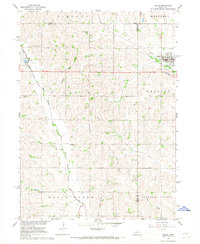
Pleasant Valley and the surrounding townships of Ridgeley, Union, and Cotterell define this mid-century agricultural landscape in Dodge County. The survey focuses on the small settlement of Webster and the community center at Clyde, illustrating a rural network of country institutions. Genealogy researchers will find several local landmarks including St Matthews Ch, Webster Ch, and Webster Cem. The landscape is etched by a series of waterways, primarily Maple Creek and Silver Creek, which are supplemented by the Scott 23 Ditch and Central Cutoff Ditch for field drainage. This map preserves the locations of local infrastructure like School No 46 and a prominent Radio Tower, reflecting the post-war era of rural development before modern consolidation changed the footprint of these Nebraska townships.
Find a feature on this map
19 named features on this map. Tap any name to fly to it.
Don’t see what you’re looking for? This feature index may not catch every label — zoom into the map to look around manually.
Map Details
Editions of this 1966 Webster Map
This is the sole edition of this map. No revisions or reprints were ever made.
Other maps of this area

1899 · Wahoo
USGS Topo · 1:125,000

1955 · Fremont
USGS Topo · 1:250,000

1957 · Fremont
USGS Topo · 1:250,000

1958 · Fremont
USGS Topo · 1:250,000

1966 · Scribner SW
USGS Topo · 1:24,000

1966 · Snyder
USGS Topo · 1:24,000

1966 · Scribner
USGS Topo · 1:24,000

1966 · Dodge SW
USGS Topo · 1:24,000
1966 · Dodge
USGS Topo · 1:24,000
1968 · Malmo NW
USGS Topo · 1:24,000