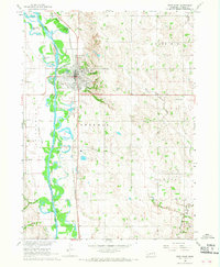
1966 Map of West Point
USGS Topo · Published 1968About this map
West Point serves as the focal point of this mid-1960s survey, situated along the eastern bank of the Elkhorn River. The landscape transitions from the river's wide floodplain, dotted with bodies of water like McKirahan Lake and Horseshoe Lake, into the rolling uplands of Garfield, Sherman, and Cuming townships. The Chicago and North Western railroad corridor parallels the river, anchoring the local economy and supporting industry near the Waterworks and Sewage Disposal sites.
Find a feature on this map
31 named features on this map. Tap any name to fly to it.
Don’t see what you’re looking for? This feature index may not catch every label — zoom into the map to look around manually.
Map Details
Editions of this 1966 West Point Map
2 editions found
Other maps of this area

1955 · Fremont
USGS Topo · 1:250,000

1957 · Fremont
USGS Topo · 1:250,000

1958 · Fremont
USGS Topo · 1:250,000

1966 · West Point NW
USGS Topo · 1:24,000

1966 · West Point SE
USGS Topo · 1:24,000

1966 · Uehling
USGS Topo · 1:24,000

1966 · Monterey
USGS Topo · 1:24,000
1966 · Beemer
USGS Topo · 1:24,000

1966 · Snyder
USGS Topo · 1:24,000

1966 · West Point NE
USGS Topo · 1:24,000