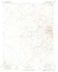
1972 Map of Montezumas Chair
USGS Topo · Published 1974About this map
Montezumas Chair rises above the high desert floor of the Navajo Indian Reservation, serving as a primary landmark in a landscape defined by seasonal drainages and remote boundary lines. Surveyed in the early 1970s, the map reveals a sparsely settled region where survival and movement are closely tied to water sources like Honey Spring and Little Water. The presence of a solitary Corral and several Jeep Trails suggests a land managed for livestock and accessed by rugged vehicles rather than paved roads. Significant boundaries, including the Joint Use Area Boundary, crisscross the area, reflecting the complex jurisdictional history of this portion of Navajo County. The winding paths of Jadito Wash and Tees Toh Wash illustrate the natural drainage patterns that dominate the arid terrain.
Find a feature on this map
11 named features on this map. Tap any name to fly to it.
Don’t see what you’re looking for? This feature index may not catch every label — zoom into the map to look around manually.
Map Details
Editions of this 1972 Montezumas Chair Map
This is the sole edition of this map. No revisions or reprints were ever made.
Other maps of this area

1883 · Tusayan
USGS Topo · 1:250,000

1886 · Tusayan
USGS Topo · 1:250,000

1947 · Flagstaff
USGS Topo · 1:250,000

1954 · Flagstaff
USGS Topo · 1:250,000

1957 · Winslow 1 SW
USGS Topo · 1:24,000

1958 · Flagstaff
USGS Topo · 1:250,000

1960 · Flagstaff
USGS Topo · 1:250,000

1962 · Flagstaff
USGS Topo · 1:250,000

1966 · Egloffstein Butte
USGS Topo · 1:62,500

1966 · Tovar Mesa
USGS Topo · 1:62,500