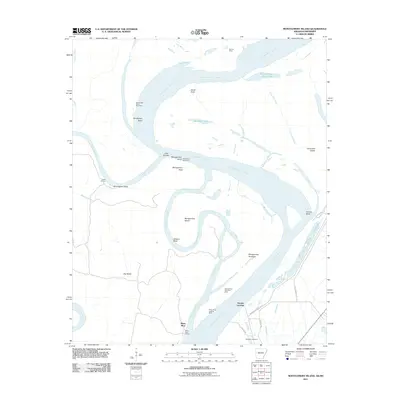
2011 Map of Montgomery Island
USGS Topo · Published 2011About this map
Montgomery Island sits at the heart of a dynamic river landscape where the Mississippi River and White River converge along the Arkansas-Mississippi border. This 2011 survey reveals an intricate network of hydraulic engineering and river morphology, from the sweeping curves of Scrubgrass Bend and Victoria Bend to the man-made Montgomery Cutoff. The map documents the critical infrastructure protecting these lowlands, including the Mississippi River Levee and various river control structures like the Henrico Dikes and Scrubgrass Bend Revetment. Along the eastern bank in Mississippi, the presence of Terrene Landing and the Rosedale Cemetery provides a touchpoint for local history near the water's edge. To the west, the expansive Big Island is crisscrossed by smaller waterways such as Mayhorn Bayou, illustrating the complex drainage patterns of the Delta region.
Find a feature on this map
38 named features on this map. Tap any name to fly to it.
Don’t see what you’re looking for? This feature index may not catch every label — zoom into the map to look around manually.
Map Details
Editions of this 2011 Montgomery Island Map
This is the sole edition of this map. No revisions or reprints were ever made.
Other maps of this area

1930 · Mellwood
USGS Topo · 1:62,500

1939 · Henrico
USGS Topo · 1:62,500

1939 · Pace
USGS Topo · 1:62,500

1939 · Big Island
USGS Topo · 1:62,500

1939 · Mellwood
USGS Topo · 1:62,500

1948 · Helena
USGS Topo · 1:250,000

1950 · Helena
USGS Topo · 1:250,000

1953 · Greenwood
USGS Topo · 1:250,000

1954 · Mellwood
USGS Topo · 1:62,500

1954 · Henrico
USGS Topo · 1:62,500