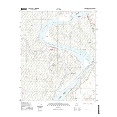
2017 Map of Montgomery Island
USGS Topo · Published 2017About this map
Mississippi River meanders and oxbows define this delta landscape along the state line between Arkansas and Mississippi. This 2017 survey illustrates the complex hydraulic geography of the region, featuring prominent landforms created by the shifting river channel such as Montgomery Island and Big Island. The map documents numerous bends and cutoffs, including Scrubgrass Bend and the Montgomery Cutoff, which illustrate the ongoing evolution of the river's path. Local navigation and access are marked by Terrene Landing Rd and Levee Rd, providing infrastructure near the riverbanks. The survey also captures smaller water bodies and bayous that remain in the alluvial plain, such as Old Tar-Paper Shack Lake and Sixmile Bayou, alongside the Rosedale Cem near the southern boundary, offering specific points of interest for genealogists and local historians tracking the development of these riverfront lands.
Find a feature on this map
48 named features on this map. Tap any name to fly to it.
Don’t see what you’re looking for? This feature index may not catch every label — zoom into the map to look around manually.
Map Details
Editions of this 2017 Montgomery Island Map
This is the sole edition of this map. No revisions or reprints were ever made.
Other maps of this area

1930 · Mellwood
USGS Topo · 1:62,500

1939 · Henrico
USGS Topo · 1:62,500

1939 · Pace
USGS Topo · 1:62,500

1939 · Big Island
USGS Topo · 1:62,500

1939 · Mellwood
USGS Topo · 1:62,500

1948 · Helena
USGS Topo · 1:250,000

1950 · Helena
USGS Topo · 1:250,000

1953 · Greenwood
USGS Topo · 1:250,000

1954 · Mellwood
USGS Topo · 1:62,500

1954 · Henrico
USGS Topo · 1:62,500