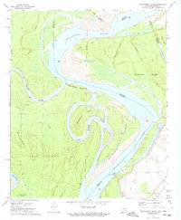
1972 Map of Montgomery Island
USGS Topo · Published 1974About this map
The confluence of the White River and Mississippi River dominates this early 1970s survey of the Arkansas-Mississippi border. This river-driven landscape is defined by its dynamic hydrology, featuring a network of cutoff lakes and sloughs such as McClellan Lake, Old Tar Paper Shack Lake, and Old River Lake. The terrain is characterized by large fluvial landmasses like Big Island and Concordia Island, which are intricately carved by waterways like Concordia Chute and Mayhorn Bayou. The eastern bank, near the Levee in Mississippi, shows signs of established settlement and infrastructure. Here, researchers can find St Pauls Ch and Rosedale Cem alongside the Terrene Landing Gaging Station. Evidence of former transportation networks is visible through the Old RR Grade, while the Landing Strip on Montgomery Towhead points to more modern utility in this frequently shifting riparian environment.
Find a feature on this map
39 named features on this map. Tap any name to fly to it.
Don’t see what you’re looking for? This feature index may not catch every label — zoom into the map to look around manually.
Map Details
Editions of this 1972 Montgomery Island Map
This is the sole edition of this map. No revisions or reprints were ever made.
Other maps of this area

1930 · Mellwood
USGS Topo · 1:62,500

1939 · Henrico
USGS Topo · 1:62,500

1939 · Pace
USGS Topo · 1:62,500

1939 · Big Island
USGS Topo · 1:62,500

1939 · Mellwood
USGS Topo · 1:62,500

1948 · Helena
USGS Topo · 1:250,000

1950 · Helena
USGS Topo · 1:250,000

1953 · Greenwood
USGS Topo · 1:250,000

1954 · Mellwood
USGS Topo · 1:62,500

1954 · Henrico
USGS Topo · 1:62,500