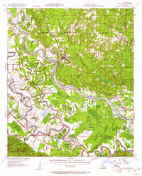
1957 Map of Montgomery
USGS Topo · Published 1961About this map
The Red River carves a winding path through this central Louisiana landscape, defining the boundaries and economic life of the mid-20th century. While the river serves as the primary artery, the Texas and Pacific and Kansas City Southern railroads provide the overland connections for settlements like Montgomery and Cloutierville. This era shows a dense network of Catholic institutional history in the river parishes, evidenced by numerous named churches and schools such as St Josephs Sch, St James Ch, and St Andrews Ch. The floodplain is a complex system of oxbow lakes and backwaters, including Cane River Lake, Hertzog Lake, and Lake Rat Bois. To the north and west, the Kisatchie National Forest covers the uplands, where the Ash-Brake 18 Lookout stands as a sentinel over the timberlands and the Forest Boundary.
Find a feature on this map
99 named features on this map. Tap any name to fly to it.
Don’t see what you’re looking for? This feature index may not catch every label — zoom into the map to look around manually.
Map Details
Editions of this 1957 Montgomery Map
3 editions found
Other maps of this area

1932 · Colfax SW
USGS Topo · 1:31,680

1932 · Colfax NW
USGS Topo · 1:31,680

1935 · Verda
USGS Topo · 1:31,680

1936 · Colfax
USGS Topo · 1:62,500

1937 · Chopin NE
USGS Topo · 1:31,680

1937 · Bermuda
USGS Topo · 1:31,680

1937 · Campti SE
USGS Topo · 1:31,680

1937 · Chopin NW
USGS Topo · 1:31,680

1937 · Aloha
USGS Topo · 1:31,680

1937 · Montgomery
USGS Topo · 1:62,500