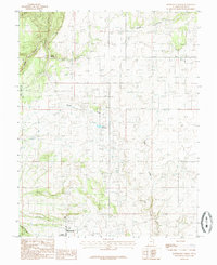
1985 Map of Monticello North
USGS Topo · Published 1985About this map
Monticello anchors the southern edge of this mid-1980s landscape, serving as a gateway to the high plateau country of San Juan County. The terrain transitions from the edges of the Manti-La Sal Nat For into a complex system of drainages, including Peters Canyon and Bridge Canyon. The local infrastructure of the era is clearly marked, showing the proximity of the County Airport and its Beacon to the town center, along with utilitarian sites like the Gravel Pit and Storage Bins.
Find a feature on this map
21 named features on this map. Tap any name to fly to it.
Don’t see what you’re looking for? This feature index may not catch every label — zoom into the map to look around manually.
Map Details
Editions of this 1985 Monticello North Map
This is the sole edition of this map. No revisions or reprints were ever made.
Other maps of this area

1885 · La Sal
USGS Topo · 1:250,000

1886 · Abajo
USGS Topo · 1:250,000

1892 · Abajo
USGS Topo · 1:250,000

1893 · Abajo
USGS Topo · 1:250,000

1954 · Mt Peale 3 SW
USGS Topo · 1:24,000

1954 · Mt Peale 3 SE
USGS Topo · 1:24,000

1954 · Mt Peale 4 SW
USGS Topo · 1:24,000
1954 · Lisbon Valley
USGS Topo · 1:62,500
1954 · Hatch Rock
USGS Topo · 1:62,500

1955 · Verdure 2 SE
USGS Topo · 1:24,000