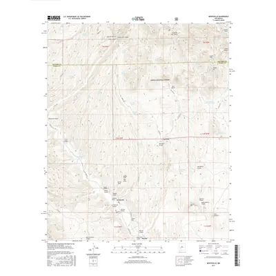
2017 Map of Monticello
USGS Topo · Published 2017About this map
Monticello sits at the base of a complex network of canyons and draws where the southern edge of the Cibola National Forest meets the high desert of Sierra County. The settlement patterns follow the drainages of Alamosa Cr and Monticello Canyon, which provided critical water in an arid landscape defined by landmarks like Aragon Hill and Seferino Hill. The map records essential water infrastructure for ranching and survival, including the Monticello Number One Tank, Stanley Well, and various natural outlets like Questa Spring. For those tracing local history or genealogy, the Monticello Cem serves as a primary landmark for the community, while smaller locales such as La Petra and Placitas illustrate the dispersed nature of habitation along the canyon floors. The terrain is marked by family-named features like Bernal Chavez Canyon and Jose Maria Canyon, reflecting a long history of land use and settlement.
Find a feature on this map
69 named features on this map. Tap any name to fly to it.
Don’t see what you’re looking for? This feature index may not catch every label — zoom into the map to look around manually.
Map Details
Editions of this 2017 Monticello Map
This is the sole edition of this map. No revisions or reprints were ever made.
Other maps of this area

1954 · Tularosa
USGS Topo · 1:250,000

1958 · Tularosa
USGS Topo · 1:250,000

1961 · Priest Tank
USGS Topo · 1:24,000

1961 · Huerfano Hill
USGS Topo · 1:24,000

1961 · Sierra Fijardo
USGS Topo · 1:24,000

1961 · Monticello
USGS Topo · 1:24,000

1964 · Vicks Peak
USGS Topo · 1:24,000

1964 · Montoya Butte
USGS Topo · 1:24,000

1964 · Steel Hill
USGS Topo · 1:24,000

1965 · Jaralosa Mountain
USGS Topo · 1:24,000