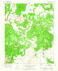
1952 Map of Montoso Peak
USGS Topo · Published 1966About this map
Caja del Rio Grant and the La Majada Grant dominate this high-desert landscape in the early 1950s, defining a region where land use was managed through expansive federal and communal holdings. A notable scientific presence is marked by the Department of Agriculture Experimental Area northwest of Montoso Peak, suggesting the area's mid-century importance for range or agricultural study.
Find a feature on this map
26 named features on this map. Tap any name to fly to it.
Don’t see what you’re looking for? This feature index may not catch every label — zoom into the map to look around manually.
Map Details
Editions of this 1952 Montoso Peak Map
4 editions found
Other maps of this area

1892 · Santa Clara
USGS Topo · 1:125,000

1951 · Agua Fria
USGS Topo · 1:24,000

1951 · Turquoise Hill
USGS Topo · 1:24,000

1952 · Turquoise Hill
USGS Topo · 1:24,000

1952 · White Rock
USGS Topo · 1:24,000

1952 · Frijoles
USGS Topo · 1:24,000

1952 · Montoso Peak
USGS Topo · 1:24,000

1953 · Cochiti Dam
USGS Topo · 1:24,000

1953 · Santo Domingo Pueblo
USGS Topo · 1:24,000

1953 · Horcado Ranch
USGS Topo · 1:24,000