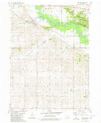
1980 Map of Montour
USGS Topo · Published 1980About this map
The Sac & Fox Indian Reservation Boundary marks a significant portion of this Tama County landscape, centered on the Mesquakie Settlement. This cultural and geographic heart is supported by essential community infrastructure, including the Sac & Fox Day Sch and McIntosh Cem. The Iowa River meanders across the northern half of the map, carving through the terrain near the township of Montour. Two major rail lines, the Chicago and North Western and the Chicago Milwaukee St Paul and Pacific, illustrate the vital transportation corridors that historically connected these rural settlements. Family history is well-represented through numerous burial grounds such as Maple Hill Cem, Korns Cem, and Rouse Cem, while the southern reaches transition into the hills of Highland and Columbia townships, drained by Richland Creek and Abes Fork.
Find a feature on this map
26 named features on this map. Tap any name to fly to it.
Don’t see what you’re looking for? This feature index may not catch every label — zoom into the map to look around manually.
Map Details
Editions of this 1980 Montour Map
This is the sole edition of this map. No revisions or reprints were ever made.
Other maps of this area

1954 · Waterloo
USGS Topo · 1:250,000

1954 · Des Moines
USGS Topo · 1:250,000

1955 · Waterloo
USGS Topo · 1:250,000

1956 · Des Moines
USGS Topo · 1:250,000

1957 · Des Moines
USGS Topo · 1:250,000

1960 · Marshalltown
USGS Topo · 1:62,500

1960 · Le Grand
USGS Topo · 1:24,000

1969 · Des Moines
USGS Topo · 1:250,000

1971 · Garwin
USGS Topo · 1:24,000
1971 · Gladbrook SE
USGS Topo · 1:24,000