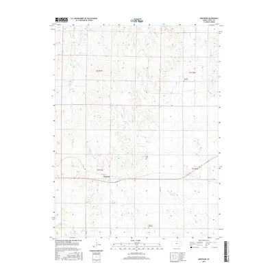
2016 Map of Montrose
USGS Topo · Published 2016About this map
Montrose serves as the central hub of this north-central Kansas landscape, situated where local drainage systems begin their descent toward larger basins. The topography is defined by the branching reaches of Johns Cr and the eastern and western forks of Marsh Creek, which carve subtle valleys through the agricultural uplands. This 2016 survey illustrates a rural environment maintained through a structured grid of county roads such as Randall Rd and S Ave, reflecting the enduring Public Land Survey System. Genealogical interest is anchored by several distinct burial sites, including Switzers Gap Cem to the north, Delta Cem near the township center, and Pleasant View Cem in the southern reaches. These locations, alongside waterways like W Marsh Cr and Spring Cr, provide essential landmarks for tracing family landholdings and the historical development of Jewell County.
Find a feature on this map
19 named features on this map. Tap any name to fly to it.
Don’t see what you’re looking for? This feature index may not catch every label — zoom into the map to look around manually.
Map Details
Editions of this 2016 Montrose Map
This is the sole edition of this map. No revisions or reprints were ever made.
Other maps of this area

1892 · Concordia
USGS Topo · 1:125,000

1894 · Mankato
USGS Topo · 1:125,000

1955 · Manhattan
USGS Topo · 1:250,000

1955 · Beloit
USGS Topo · 1:250,000

1956 · Manhattan
USGS Topo · 1:250,000

1957 · Manhattan
USGS Topo · 1:250,000

1959 · Beloit
USGS Topo · 1:250,000
1968 · Jamestown NW
USGS Topo · 1:24,000
1969 · Randall
USGS Topo · 1:24,000

1969 · Mankato
USGS Topo · 1:24,000