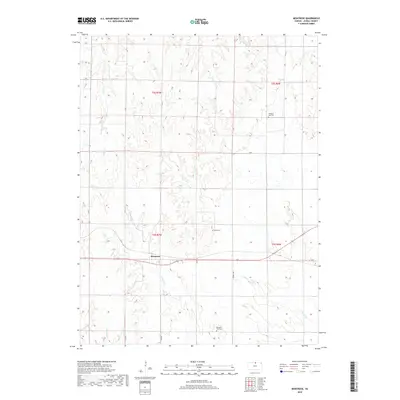
2018 Map of Montrose
USGS Topo · Published 2018About this map
Montrose serves as the central hub of this north-central Kansas landscape, situated where the high plains begin to break into the drainage basins of the Republican River watershed. The terrain is defined by a dendritic network of seasonal and perennial watercourses, including the north-flowing Johns Cr and the diverging branches of E Marsh Cr and W Marsh Cr. These waterways carve into the agricultural plateau, creating the distinct relief that characterizes Jewell County.
Find a feature on this map
17 named features on this map. Tap any name to fly to it.
Don’t see what you’re looking for? This feature index may not catch every label — zoom into the map to look around manually.
Map Details
Editions of this 2018 Montrose Map
This is the sole edition of this map. No revisions or reprints were ever made.
Other maps of this area

1892 · Concordia
USGS Topo · 1:125,000

1894 · Mankato
USGS Topo · 1:125,000

1955 · Manhattan
USGS Topo · 1:250,000

1955 · Beloit
USGS Topo · 1:250,000

1956 · Manhattan
USGS Topo · 1:250,000

1957 · Manhattan
USGS Topo · 1:250,000

1959 · Beloit
USGS Topo · 1:250,000
1968 · Jamestown NW
USGS Topo · 1:24,000
1969 · Randall
USGS Topo · 1:24,000

1969 · Mankato
USGS Topo · 1:24,000