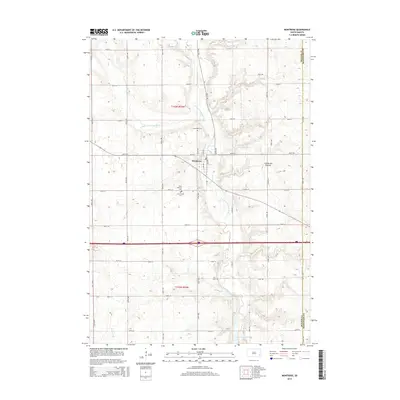
2015 Map of Montrose
USGS Topo · Published 2015About this map
Montrose sits at the confluence of several vital South Dakota waterways, serving as the primary hub of this eastern McCook County landscape. The town is bounded by the Little Vermillion River and the East Fork Vermillion River, which wind through the township before feeding into East Vermillion Lake to the southeast. This geography is defined by its position on the Coteau des Prairies, a high plateau that shapes the drainage patterns of local streams like Battle Cr. For those researching local lineages, the map identifies several significant burial grounds located just outside the main settlement, including Montrose Cem, Saint Patricks Cem, and Saint Patrick Cem. The surrounding sections are organized by an orderly grid of rural routes such as Valley Rd and Duck Rd, reflecting the enduring agricultural character of the region as it transitioned into the twenty-first century.
Find a feature on this map
37 named features on this map. Tap any name to fly to it.
Don’t see what you’re looking for? This feature index may not catch every label — zoom into the map to look around manually.
Map Details
Editions of this 2015 Montrose Map
This is the sole edition of this map. No revisions or reprints were ever made.
Other maps of this area

1955 · Sioux Falls
USGS Topo · 1:250,000

1958 · Sioux Falls
USGS Topo · 1:250,000

1964 · Montrose
USGS Topo · 1:24,000

1964 · Grass Lake
USGS Topo · 1:24,000

1964 · Canistota
USGS Topo · 1:24,000

1964 · Salem NE
USGS Topo · 1:24,000

1964 · Humboldt
USGS Topo · 1:24,000

1964 · East Vermillion Lake
USGS Topo · 1:24,000
1968 · Buffalo Trading Post
USGS Topo · 1:24,000

1968 · Lake Madison SW
USGS Topo · 1:24,000