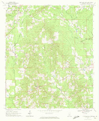
1970 Map of Montrose South
USGS Topo · Published 1972About this map
Bienville National Forest dominates the northwestern corner of this landscape, where the Gulf Mobile and Ohio railroad corridor passes through the town of Louin. The terrain is defined by the branching networks of Tallahala Creek and Nuakfuppa Creek, with small settlements and family cemeteries scattered throughout the rural landscape. Significant cultural landmarks include the Bay Springs Country Club and several country churches like Palestine Ch and Mulberry Ch. Local industry is evidenced by the presence of a Pipeline crossing the eastern sections and scattered Oil Well locations. For genealogists, the map preserves the exact locations of numerous burial sites, including the St Paul Cem, McCarty Cem, and Old Hatch Cem, which often represent the only remaining physical markers of early family homesteads and community nodes in Jasper County.
Find a feature on this map
30 named features on this map. Tap any name to fly to it.
Don’t see what you’re looking for? This feature index may not catch every label — zoom into the map to look around manually.
Map Details
Editions of this 1970 Montrose South Map
This is the sole edition of this map. No revisions or reprints were ever made.
Other maps of this area

1953 · Hattiesburg
USGS Topo · 1:250,000

1953 · Meridian
USGS Topo · 1:250,000

1957 · Meridian
USGS Topo · 1:250,000

1958 · Hattiesburg
USGS Topo · 1:250,000

1963 · Waldrup
USGS Topo · 1:24,000

1964 · Lake Como
USGS Topo · 1:24,000

1965 · Meridian
USGS Topo · 1:250,000

1968 · Clear Springs
USGS Topo · 1:24,000

1968 · Louin
USGS Topo · 1:24,000

1970 · Paulding
USGS Topo · 1:24,000