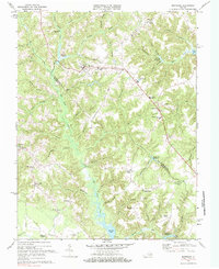
1968 Map of Montross
USGS Topo · Published 1985About this map
Montross serves as the focal point of this coastal plain landscape, situated along the ridge line where the tributaries of the Potomac and Rappahannock rivers begin their descent. The map illustrates a rural Virginia economy defined by water management and education, featuring Chandlers Millpond, Weavers Millpond, and Omokundra Millpond. These millponds, along with the extensive wetlands of Kenna Swamp and Lawrence Swamp, dictated the historical placement of roads and small communities like Zacata and Farmers Fork.
Find a feature on this map
78 named features on this map. Tap any name to fly to it.
Don’t see what you’re looking for? This feature index may not catch every label — zoom into the map to look around manually.
Map Details
Editions of this 1968 Montross Map
2 editions found
Other maps of this area

1892 · Piney Point
USGS Topo · 1:62,500

1892 · Montross
USGS Topo · 1:62,500

1894 · Piney Point
USGS Topo · 1:62,500

1895 · Nomini
USGS Topo · 1:125,000

1895 · Piney Point
USGS Topo · 1:62,500

1895 · Montross
USGS Topo · 1:62,500

1898 · Nomini
USGS Topo · 1:125,000

1901 · Piney Point
USGS Topo · 1:62,500

1917 · Morattico
USGS Topo · 1:62,500

1918 · Tappahannock
USGS Topo · 1:62,500