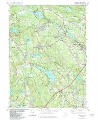
1983 Map of Montville
USGS Topo · Published 1984About this map
Montville Center and Palmertown serve as focal points for this late-twentieth-century study of the New London County interior. The landscape is defined by its extensive water network, where industrial and municipal history is etched into the geography of Oxoboxo Lake, Konomoc Lake, and Bogue Brook Res. The suburban evolution of the early 1980s is evident in the residential expansion of Montville Manor and Oakdale Heights, yet the map retains significant traces of its earlier rural character through older nodes like Chesterfield and Macks Mill. To the west, the Nehantic State Forest preserves a large tract of undeveloped terrain, contrasting with the active utility corridors and numerous gravel operations found throughout the quadrangle. Educational and civic infrastructure, from the Montville High Sch to several local cemeteries, provides a grounded look at the community's structural layout before modern development further altered the region's historic hills.
Find a feature on this map
96 named features on this map. Tap any name to fly to it.
Don’t see what you’re looking for? This feature index may not catch every label — zoom into the map to look around manually.
Map Details
Editions of this 1983 Montville Map
This is the sole edition of this map. No revisions or reprints were ever made.
Other maps of this area

1892 · New London
USGS Topo · 1:62,500

1892 · Norwich
USGS Topo · 1:62,500

1892 · Gilead
USGS Topo · 1:62,500

1893 · New London
USGS Topo · 1:62,500

1893 · Saybrook
USGS Topo · 1:62,500

1921 · New London
USGS Topo · 1:62,500

1934 · Niantic
USGS Topo · 1:24,000

1935 · Montville
USGS Topo · 1:24,000

1938 · New London
USGS Topo · 1:31,680

1938 · Niantic
USGS Topo · 1:62,500