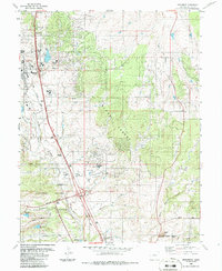
1986 Map of Monument
USGS Topo · Published 1986About this map
The United States Air Force Academy grounds dominate the southern portion of this mid-1980s landscape, featuring specialized military landmarks like the B-52 Exhibit and training routes such as Lehman Run and Parade Loop. The settlement patterns of Monument and Palmer Lake are clearly defined along the western edge, following the corridor of the Denver and Rio Grande Western Railroad. To the east, the terrain transitions into the dense Black Forest, a stark contrast to the developed academy grounds and the residential growth near Lewis Palmer High School. Evidence of earlier infrastructure and industry persists through the Old Railroad Grade and a claypit near the academy boundary. Water management is central to the area's layout, shown through a series of numbered reservoirs including Reservoir No 1 and various creeks like Monument Creek and Black Squirrel Creek that drain the front range foothills.
Find a feature on this map
38 named features on this map. Tap any name to fly to it.
Don’t see what you’re looking for? This feature index may not catch every label — zoom into the map to look around manually.
Map Details
Editions of this 1986 Monument Map
This is the sole edition of this map. No revisions or reprints were ever made.
Other maps of this area

1893 · Colorado Springs
USGS Topo · 1:125,000

1894 · Castle Rock
USGS Topo · 1:125,000

1909 · Colorado Springs
USGS Topo · 1:125,000

1913 · Castle Rock
USGS Topo · 1:125,000

1940 · Elbert
USGS Topo · 1:62,500

1942 · Colorado Springs
USGS Topo · 1:125,000

1944 · Elbert
USGS Topo · 1:62,500

1948 · Colorado Springs
USGS Topo · 1:62,500

1948 · Pikeview
USGS Topo · 1:24,000
1948 · Cascade
USGS Topo · 1:24,000