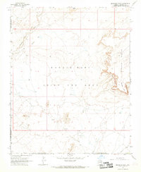
1967 Map of Monument Point
USGS Topo · Published 1969About this map
Navajo Hopi Joint Use Area lands dominate this 1960s landscape, illustrating a complex period of shared territorial administration in Coconino County. The terrain is defined by the drainage of Dinnebito Wash and expansive fields of Sand Dunes that shift across the high desert floor. To the east, the topography rises sharply into the Garces Mesas, where the jagged escarpments of the Kachina Points and Kachina Point overlook the lower plains. Evidence of human activity and adaptation is sparse but significant, with Ruins noted near the mesa edges, suggesting ancient habitation sites. Modern land use is represented by isolated ranching infrastructure, including a Corral, a Dry Well, and several Dry Wells, which mark the limited water resources available to inhabitants and livestock within the reservation boundaries during this era.
Find a feature on this map
12 named features on this map. Tap any name to fly to it.
Don’t see what you’re looking for? This feature index may not catch every label — zoom into the map to look around manually.
Map Details
Editions of this 1967 Monument Point Map
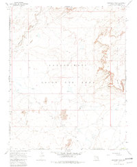
2 editions found
Other maps of this area

1883 · Tusayan
USGS Topo · 1:250,000

1886 · Tusayan
USGS Topo · 1:250,000

1886 · San Francisco Mtns
USGS Topo · 1:250,000

1891 · San Francisco Mtns
USGS Topo · 1:250,000

1894 · San Francisco Mtns
USGS Topo · 1:250,000

1899 · San Francisco Mtns
USGS Topo · 1:250,000

1947 · Flagstaff
USGS Topo · 1:250,000

1954 · Flagstaff
USGS Topo · 1:250,000

1955 · Grand Falls NE
USGS Topo · 1:24,000
1955 · Black Falls 4 SE
USGS Topo · 1:24,000