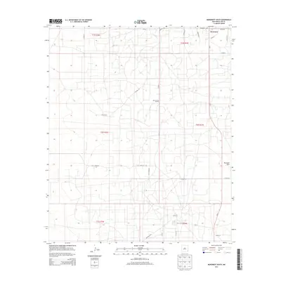
2013 Map of Monument South
USGS Topo · Published 2013About this map
The town of Monument sits at the northern edge of this high plains landscape, defined by the industrial footprint of the Monument-Jal Oil Field. This 2013 survey reveals a highly organized grid of rural routes and energy infrastructure, where the natural terrain is dominated by the broad, low depression of Monument Draw. The map details a complex network of local transport, including Monument Hwy and family-named landmarks like the Record Ranch. Local transit is further documented by specific thoroughfares such as Tuffy Copper Rd and Tuffy Cooper Rd, which serve the expansive oil fields and ranching properties. The systematic division of the land into townships like t20s r36e and t21s r36e underscores the geometric precision of the New Mexico interior during the early 21st century.
Find a feature on this map
28 named features on this map. Tap any name to fly to it.
Don’t see what you’re looking for? This feature index may not catch every label — zoom into the map to look around manually.
Map Details
Editions of this 2013 Monument South Map
This is the sole edition of this map. No revisions or reprints were ever made.
Other maps of this area

1954 · Hobbs
USGS Topo · 1:250,000

1958 · Hobbs
USGS Topo · 1:250,000

1963 · Oil Center
USGS Topo · 1:62,500

1963 · Monument
USGS Topo · 1:62,500

1969 · Hobbs SW
USGS Topo · 1:24,000

1969 · Eunice
USGS Topo · 1:24,000

1969 · Hobbs West
USGS Topo · 1:24,000

1978 · Jal
USGS Topo · 1:100,000

1984 · Oil Center
USGS Topo · 1:24,000
1984 · San Simon Ranch
USGS Topo · 1:24,000