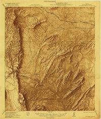
1921 Map of Monument Spring
USGS Topo · Published 1921About this map
Old Fort Pena Colorado stands as a focal point in this 1921 survey of the Trans-Pecos region, situated along the Pena Colorado Creek. The landscape is dominated by the massive ridge lines of the Del Norte Mountains and the northern edge of the Santiago Mountains, which channeled early movement through the high desert. The transportation network of the era is clearly defined by the Southern Pacific System and the Galveston Harrisburg and San Antonio RR, providing vital connections for ranching operations like the Combs Headquarters Ranch and Decie Ranch. Grounded in work by surveyors like R.C. Seitz and R.R. Monbeck, the map records essential water sources including Sunshine Springs, Mud Spring, and the namesake Monument Spring, which were critical to the survival of the scattered cattle ranches and the burgeoning town of Marathon.
Find a feature on this map
38 named features on this map. Tap any name to fly to it.
Don’t see what you’re looking for? This feature index may not catch every label — zoom into the map to look around manually.
Map Details
Editions of this 1921 Monument Spring Map
4 editions found

Other maps of this area

1895 · Alpine
USGS Topo · 1:125,000

1917 · Santiago Peak
USGS Topo · 1:62,500

1917 · Buck Hill
USGS Topo · 1:62,500

1917 · Hood Spring
USGS Topo · 1:62,500

1918 · Bone Spring
USGS Topo · 1:125,000

1918 · Hood Spring
USGS Topo · 1:62,500

1918 · Buck Hill
USGS Topo · 1:62,500

1918 · Santiago Peak
USGS Topo · 1:62,500

1920 · Monument Spring
USGS Topo · 1:62,500

1920 · Marathon
USGS Topo · 1:62,500