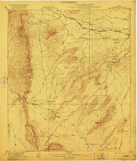
1921 Map of Monument Spring
USGS Topo · Published 1922About this map
The Del Norte Mountains and Santiago Mountains anchor this early 1920s topography of Brewster County, revealing a landscape defined by isolated ranching outposts and strategic water sources. The Southern Pacific System rail line cuts across the northern reaches, connecting the settlement of Lenox to the wider region. Below the peaks, a network of historic homesteads like the Old Payne Ranch, Bourland Ranch, and Combs Headquarters Ranch sit near vital desert water points such as Monument Spring and Simpson Springs.
Find a feature on this map
37 named features on this map. Tap any name to fly to it.
Don’t see what you’re looking for? This feature index may not catch every label — zoom into the map to look around manually.
Map Details
Editions of this 1921 Monument Spring Map
4 editions found

Other maps of this area

1895 · Alpine
USGS Topo · 1:125,000

1917 · Santiago Peak
USGS Topo · 1:62,500

1917 · Buck Hill
USGS Topo · 1:62,500

1917 · Hood Spring
USGS Topo · 1:62,500

1918 · Bone Spring
USGS Topo · 1:125,000

1918 · Hood Spring
USGS Topo · 1:62,500

1918 · Buck Hill
USGS Topo · 1:62,500

1918 · Santiago Peak
USGS Topo · 1:62,500

1920 · Monument Spring
USGS Topo · 1:62,500

1920 · Marathon
USGS Topo · 1:62,500