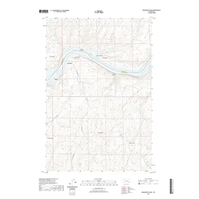
2020 Map of Monumental Rock
USGS Topo · Published 2020About this map
Monumental Rock rises as a prominent landmark on the south bank of the Snake River, anchoring a landscape where the river carves through high plateau country along the Franklin Co and Walla Walla Co line. The settlement of Ruxby and the nearby locale of Magallon sit nestled within the drainage breaks south of Lake Herbert G. West. This 2020 survey illustrates the modern land use patterns of the region, where the steep topography of Skookum Canyon and Cow Bar Canyon dictates the path of local corridors like Magallon Rd and Casey Rd. To the south, Walker Canyon cuts deep into the terrain, highlighting the geological transition from the river valley to the uplands. The presence of Three Springs Bar suggests the historical importance of river access points in this corner of Washington, where geography and hydrology have long shaped human habitation and transport.
Find a feature on this map
17 named features on this map. Tap any name to fly to it.
Don’t see what you’re looking for? This feature index may not catch every label — zoom into the map to look around manually.
Map Details
Editions of this 2020 Monumental Rock Map
This is the sole edition of this map. No revisions or reprints were ever made.
Other maps of this area

1915 · Wallulah
USGS Topo · 1:96,000

1916 · Connell
USGS Topo · 1:125,000

1918 · Connell
USGS Topo · 1:125,000

1918 · Wallula
USGS Topo · 1:125,000

1919 · Walla Walla
USGS Topo · 1:125,000

1921 · Walla Walla
USGS Topo · 1:125,000

1948 · Ayer
USGS Topo · 1:62,500

1950 · Haas
USGS Topo · 1:62,500

1953 · Walla Walla
USGS Topo · 1:250,000

1958 · Walla Walla
USGS Topo · 1:250,000