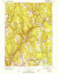
1952 Map of Moodus
USGS Topo · Published 1953About this map
Moodus and the surrounding river valleys of central Connecticut are shown here during a period of transition, following the 1952 revision of topographic data. The Salmon River and its many tributaries, including Dickinson Brook and Blackledge River, define the local topography, punctuated by prominent elevations like Bull Hill. Transportation networks are dominated by the New York New Haven and Hartford railroad line, which skirts the northern edges of the Salmon River State Forest. Notable for local historians are the numerous small burying grounds such as Ponemah Cem and Westchester Cem, along with landmarks like the Old Comstock Bridge. The map details the dense collection of ponds and swamps in the southeastern corner, including Babcock Pond and Thousand Acre Pond, illustrating the intricate drainage patterns that supported early milling and settlement in East Haddam and Colchester.
Find a feature on this map
59 named features on this map. Tap any name to fly to it.
Don’t see what you’re looking for? This feature index may not catch every label — zoom into the map to look around manually.
Map Details
Editions of this 1952 Moodus Map
3 editions found
Other maps of this area

1892 · Gilead
USGS Topo · 1:62,500

1893 · Guilford
USGS Topo · 1:62,500

1893 · Middletown
USGS Topo · 1:62,500

1893 · Saybrook
USGS Topo · 1:62,500

1906 · Farmington
USGS Topo · 1:125,000

1928 · Glastonbury
USGS Topo · 1:24,000

1944 · Marlboro
USGS Topo · 1:31,680

1944 · Columbia
USGS Topo · 1:31,680

1944 · Deep River
USGS Topo · 1:31,680

1945 · Middle Haddam
USGS Topo · 1:31,680