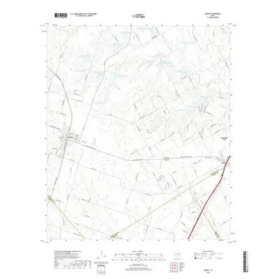
2019 Map of Moody
USGS Topo · Published 2019About this map
Moody and Bruceville-Eddy anchor this Central Texas landscape where the borders of McLennan, Bell, and Falls counties converge. The terrain is defined by a dense network of hydrologic management, featuring over a dozen Soil Conservation Service reservoirs including Soil Conservation Service Site 17 Reservoir and the John M Brinegar Reservoir. These man-made features work alongside natural drainages like S Cow Bayou and Big Elm Cr to manage the local watershed.
Find a feature on this map
108 named features on this map. Tap any name to fly to it.
Don’t see what you’re looking for? This feature index may not catch every label — zoom into the map to look around manually.
Map Details
Editions of this 2019 Moody Map
This is the sole edition of this map. No revisions or reprints were ever made.
Other maps of this area

1892 · Temple
USGS Topo · 1:125,000

1924 · Temple 2-C
USGS Topo · 1:48,000

1924 · Temple 3-B
USGS Topo · 1:48,000

1931 · Mc Gregor
USGS Topo · 1:62,500

1931 · Belton
USGS Topo · 1:62,500

1954 · Waco
USGS Topo · 1:250,000

1955 · Waco
USGS Topo · 1:250,000

1957 · Bruceville
USGS Topo · 1:24,000

1957 · Lorena
USGS Topo · 1:24,000
1963 · Belfalls
USGS Topo · 1:24,000