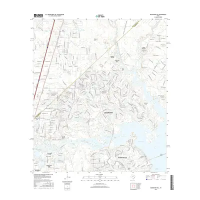
2016 Map of Moonshine Hill
USGS Topo · Published 2016About this map
Moonshine Hill and the expanding residential corridors of Atascocita anchor this modern survey of the northeastern Houston metropolitan area. The landscape is defined by the extensive waters of Lake Houston and the East Fork San Jacinto River, where numerous residential developments such as River Terrace, Walden Woods, and Dogwood Acres have integrated into the riparian environment. Significant local history is preserved at the White Oak Cem near Porter, situated just north of the Montgomery Co and Harris Co boundary line. The map reveals a complex network of waterways, including Artesian Slough and Maple Slough, winding through a terrain marked by deep drainage features like Robinson Gully and Taylor Gully. This document illustrates the contemporary suburban pattern of the region, where legacy place names like Shadow Lake and Riverside Crest persist alongside major transit arteries like US Hwy 59 Bus.
Find a feature on this map
104 named features on this map. Tap any name to fly to it.
Don’t see what you’re looking for? This feature index may not catch every label — zoom into the map to look around manually.
Map Details
Editions of this 2016 Moonshine Hill Map
This is the sole edition of this map. No revisions or reprints were ever made.
Other maps of this area

1916 · Crosby
USGS Topo · 1:24,000

1916 · Harmaston
USGS Topo · 1:24,000

1916 · Moonshine Hill
USGS Topo · 1:24,000

1916 · Huffman
USGS Topo · 1:24,000

1916 · Humble
USGS Topo · 1:24,000

1919 · Humble
USGS Topo · 1:31,680

1919 · Weeden
USGS Topo · 1:31,680

1919 · Crosby
USGS Topo · 1:31,680

1920 · Harmaston
USGS Topo · 1:31,680

1920 · Moonshine Hill
USGS Topo · 1:31,680