
1892 Map of Moore
USGS Topo · Published 1892About this map
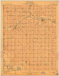
The Atchison Topeka and Santa Fe Rail Road provides the primary north-south artery through this territorial landscape, where the settlement of Moore sits at the junction of rail and trail. Surveyed just three years after the land run, the map documents the early transition from open prairie to organized townships. The northern boundary is defined by the winding course of the North Fork Canadian River and its tributary, Crutcho Creek, while the southern reaches are drained by the Little River. Sparse settlements such as Chaddick and Berry represent the first generation of rural nodes appearing along section lines. This document captures the precise moment when the Oklahoma Co Cleveland Co boundary was being established through the varied terrain of the Boone and Crutcho districts.
Find a feature on this map
16 named features on this map. Tap any name to fly to it.
Don’t see what you’re looking for? This feature index may not catch every label — zoom into the map to look around manually.
Map Details
Editions of this 1892 Moore Map
This is the sole edition of this map. No revisions or reprints were ever made.
Other maps of this area

1892 · Edmond
USGS Topo · 1:62,500

1892 · Kingfisher
USGS Topo · 1:125,000

1893 · Norman
USGS Topo · 1:62,500

1893 · Oklahoma City
USGS Topo · 1:62,500

1895 · Kingfisher
USGS Topo · 1:125,000

1898 · Purcell
USGS Topo · 1:125,000

1904 · Chickasha
USGS Topo · 1:125,000
1909 · Luther
USGS Topo · 1:62,500
1910 · McComb
USGS Topo · 1:62,500

1925 · Norman NO 2
USGS Topo · 1:24,000