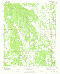
1973 Map of Mooreville
USGS Topo · Published 1975About this map
Mooreville sits near the crossing of local routes in this 1970s landscape, serving as a hub for the surrounding rural communities of Eggville, Shiloh, and Dorsey. The terrain is defined by the winding paths of Mantachie Creek and Boguefala Creek, which drain a patchwork of wooded hills and small farms. This survey captures a moment when the regional infrastructure included the Lee Lookout Tower and a Landing Strip near Eggville Ch, reflecting a mix of forestry management and local utility.
Find a feature on this map
49 named features on this map. Tap any name to fly to it.
Don’t see what you’re looking for? This feature index may not catch every label — zoom into the map to look around manually.
Map Details
Editions of this 1973 Mooreville Map
This is the sole edition of this map. No revisions or reprints were ever made.
Other maps of this area

1921 · Tupelo
USGS Topo · 1:48,000

1923 · Tupelo
USGS Topo · 1:62,500

1956 · Tupelo
USGS Topo · 1:250,000

1958 · Tupelo
USGS Topo · 1:250,000

1965 · Mooreville
USGS Topo · 1:24,000

1965 · Fulton
USGS Topo · 1:24,000

1965 · Kirkville
USGS Topo · 1:24,000

1966 · Beans Ferry
USGS Topo · 1:24,000

1966 · Evergreen
USGS Topo · 1:24,000

1966 · Verona
USGS Topo · 1:24,000