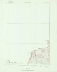
1927 Map of Moose Bog
USGS Topo · Published 1969About this map
Quebec and international borders converge in this remote northern frontier, where the topography of Pittsburg and Oxford County was meticulously surveyed by the International Boundary Commission. The landscape is defined by the high elevations of Mount D'Urban and Saddle Hill, which dictate the flow of the Magalloway River and its multiple branches. Remote outposts like Bowman Farm and Moose Bog Camp provide the only evidence of permanent human presence in an area dominated by peatlands and high-altitude water bodies. Genealogists and historians can trace the early drainage patterns around Moose Bog and the numerous small basins like Bowman Ponds and Barker Pond that characterize this borderland wilderness before more modern development reached the deep woods of the Northeast.
Find a feature on this map
26 named features on this map. Tap any name to fly to it.
Don’t see what you’re looking for? This feature index may not catch every label — zoom into the map to look around manually.
Map Details
Editions of this 1927 Moose Bog Map
3 editions found
Other maps of this area

1925 · Indian Stream
USGS Topo · 1:48,000

1926 · Indian Stream
USGS Topo · 1:62,500

1927 · Indian Stream
USGS Topo · 1:62,500

1927 · Moose Bog
USGS Topo · 1:48,000

1927 · Second Lake
USGS Topo · 1:62,500

1931 · Cupsuptic
USGS Topo · 1:48,000

1931 · Moose Bog
USGS Topo · 1:62,500

1932 · Second Lake
USGS Topo · 1:62,500

1932 · Arnold Pond
USGS Topo · 1:48,000

1934 · Cupsuptic
USGS Topo · 1:62,500