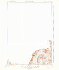
1931 Map of Moose Bog
USGS Topo · Published 1936About this map
Canada United States international boundaries define the northwestern edge of this 1927 survey, where the heights of Mt Bon Durban and Saddle Hill overlook a landscape of high-elevation bogs and drainages. The Magalloway River system dominates the local topography, fed by the West Branch, Third Branch, and East Branch as they flow through the Bowman and Parmachenee townships. This is a region of isolated outposts and topographical landmarks, where the Bowman Farm stands as one of the few named human developments amidst the complex hydrology of Moose Bog and Moose Brook.
Find a feature on this map
24 named features on this map. Tap any name to fly to it.
Don’t see what you’re looking for? This feature index may not catch every label — zoom into the map to look around manually.
Map Details
Editions of this 1931 Moose Bog Map
5 editions found
Other maps of this area

1925 · Indian Stream
USGS Topo · 1:48,000

1926 · Indian Stream
USGS Topo · 1:62,500

1927 · Indian Stream
USGS Topo · 1:62,500

1927 · Moose Bog
USGS Topo · 1:48,000

1927 · Second Lake
USGS Topo · 1:62,500

1931 · Cupsuptic
USGS Topo · 1:48,000

1931 · Moose Bog
USGS Topo · 1:62,500

1932 · Second Lake
USGS Topo · 1:62,500

1932 · Arnold Pond
USGS Topo · 1:48,000

1934 · Cupsuptic
USGS Topo · 1:62,500