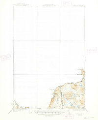
1931 Map of Moose Bog
USGS Topo · Published 1947About this map
The rugged international borderlands of Pittsburg and the Maine-New Hampshire line define this 1927 survey, reflecting a landscape where geography and political boundaries intersect at the edge of the Canadian border. The drainage of the West Branch Magalloway River and the Third East Branch Magalloway River dominates the terrain, centering on the vast wetlands of Moose Bog Camp and the high points of Bowman Hill and Saddle Hill.
Find a feature on this map
24 named features on this map. Tap any name to fly to it.
Don’t see what you’re looking for? This feature index may not catch every label — zoom into the map to look around manually.
Map Details
Editions of this 1931 Moose Bog Map
5 editions found
Other maps of this area

1925 · Indian Stream
USGS Topo · 1:48,000

1926 · Indian Stream
USGS Topo · 1:62,500

1927 · Indian Stream
USGS Topo · 1:62,500

1927 · Moose Bog
USGS Topo · 1:48,000

1927 · Second Lake
USGS Topo · 1:62,500

1931 · Cupsuptic
USGS Topo · 1:48,000

1931 · Moose Bog
USGS Topo · 1:62,500

1932 · Second Lake
USGS Topo · 1:62,500

1932 · Arnold Pond
USGS Topo · 1:48,000

1934 · Cupsuptic
USGS Topo · 1:62,500