
1978 Map of Moose Butte
USGS Topo · Published 1978About this map
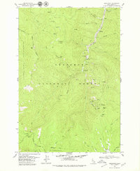
Nez Perce National Forest dominates this topographic study of Idaho's high country, where the landscape is defined by the complex drainage of the Red River. The map documents a rugged wilderness carved by water, showing the convergence of the West Fork Red River, Middle Fork Red River, and South Fork Red River. Evidence of previous resource extraction is visible along the northern river banks, most notably the Dredge Tailings and the Old Portland Mine located near the headwaters of Relief Creek. This 1978 edition records a transition in forest management, where mechanized transport is restricted to scattered Jeep Trails while older Pack Trails remain the primary means of reaching peaks like Moose Butte and Porters Mtn. The detailed topography illustrates the isolation of this mining and timber region before modern infrastructure reached deep into the drainage basins of Deer Creek and Moose Meadow Creek.
Find a feature on this map
27 named features on this map. Tap any name to fly to it.
Don’t see what you’re looking for? This feature index may not catch every label — zoom into the map to look around manually.
Map Details
Editions of this 1978 Moose Butte Map
This is the sole edition of this map. No revisions or reprints were ever made.
Other maps of this area

1931 · Buffalo Hump
USGS Topo · 1:125,000

1934 · Buffalo Hump
USGS Topo · 1:125,000

1956 · Elk City
USGS Topo · 1:250,000

1960 · Elk City
USGS Topo · 1:250,000

1962 · Center Star Mtn
USGS Topo · 1:24,000

1966 · Elk City
USGS Topo · 1:24,000

1966 · Black Hawk Mtn
USGS Topo · 1:24,000

1977 · Silver Spur Ridge
USGS Topo · 1:24,000

1978 · Trapper Creek
USGS Topo · 1:24,000
1979 · Orogrande
USGS Topo · 1:24,000