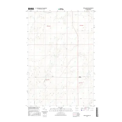
2015 Map of Moose Junction
USGS Topo · Published 2015About this map
Belden Swamp dominates the northern reaches of this northwestern Wisconsin landscape, feeding a complex network of waterways including the Spruce River and Toad Cr. The terrain is defined by its drainage patterns, where the headwaters of the Upper Tamarack River and Dingle Cr carve through the glacial till. The small settlement of Moose Junction serves as the primary focal point, situated at the intersection of local routes like Moose Rd and E Co Rd M. This survey illustrates a contemporary landscape still heavily shaped by its natural hydrology, with sparsely distributed roads such as Mihna Rd and Cummings Rd providing access to the wooded interior. The preservation of drainage features like Chases Brook alongside seasonal paths like E Summit Trl highlights the area's transition from a wild marshland to a managed rural corridor.
Find a feature on this map
17 named features on this map. Tap any name to fly to it.
Don’t see what you’re looking for? This feature index may not catch every label — zoom into the map to look around manually.
Map Details
Editions of this 2015 Moose Junction Map
This is the sole edition of this map. No revisions or reprints were ever made.
Other maps of this area

1949 · Danbury
USGS Topo · 1:48,000

1949 · Holyoke
USGS Topo · 1:48,000

1949 · Webb Lake
USGS Topo · 1:48,000

1949 · Patzau
USGS Topo · 1:48,000

1953 · Duluth
USGS Topo · 1:250,000

1954 · Foxboro
USGS Topo · 1:24,000

1954 · Amnicon Lake
USGS Topo · 1:24,000
1954 · Patzau
USGS Topo · 1:24,000

1955 · Webb Lake
USGS Topo · 1:62,500

1955 · Patzau
USGS Topo · 1:62,500