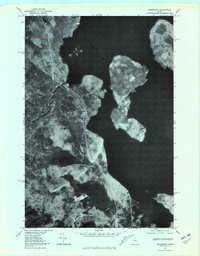
1977 Map of Moosehead
USGS Topo · Published 1981About this map
Moosehead Lake dominates this late-1970s orthophotoquad, revealing the complex shoreline and islands of Maine’s interior timberlands. This specialized aerial imagery provides a direct look at the wooded landscape at the headwaters of the Kennebec River, where the forest meets the water's edge without the abstraction of traditional contour lines. The map captures the massive profiles of Deer Island and the southern tip of Sugar Island, while the western shore is defined by the steep rise of Big Squaw Mountain. Smaller water bodies like Burnham Pond and Mountain View Pond sit isolated in the dense canopy, connected only by narrow logging tracks or natural drainages. This perspective is particularly valuable for tracing the exact 1977 vegetation patterns and shoreline configurations before decades of subsequent forest growth and shoreline development changed the local character.
Find a feature on this map
7 named features on this map. Tap any name to fly to it.
Don’t see what you’re looking for? This feature index may not catch every label — zoom into the map to look around manually.
Map Details
Editions of this 1977 Moosehead Map
This is the sole edition of this map. No revisions or reprints were ever made.
Other maps of this area

1905 · The Forks
USGS Topo · 1:62,500

1907 · The Forks
USGS Topo · 1:62,500

1920 · Moosehead Lake
USGS Topo · 1:62,500

1921 · Brassua Lake
USGS Topo · 1:62,500

1922 · Moosehead Lake
USGS Topo · 1:62,500

1923 · Brassua Lake
USGS Topo · 1:62,500

1930 · Moosehead Lake
USGS Topo · 1:62,500

1944 · Brassua Lake
USGS Topo · 1:62,500

1944 · Moosehead Lake
USGS Topo · 1:62,500

1951 · Greenville
USGS Topo · 1:62,500
Featured Places
- Misery Gore, ME
- Sapling Township, ME
- Big Moose Township, ME
- Sandbar Tract Township, ME
- Harfords Point Township, ME