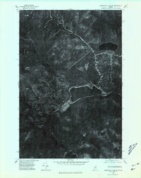
1975 Map of Mooseleuk Lake NE
USGS Topo · Published 1981About this map
Big Machias Lake and its surrounding northern Maine timberlands are captured in this mid-1970s orthophotoquad, showing a landscape defined by industrial forestry and vast water systems. The imagery highlights the network of logging roads and clearings that connect Clayton Lake in the north to the larger waters of Big Machias Lake and Pratt Lake in the south. Unlike traditional topographic maps, this aerial perspective provides a literal view of the forest canopy and drainage patterns during the autumn of 1975, revealing the exact footprint of human intervention in the North Woods. Waterways like the Machias River and Twentymile Brook appear as dark ribbons through the dense growth, while smaller features such as Mc Gowan Pond and Rowe Lake sit within the complex watershed of the Aroostook region.
Find a feature on this map
8 named features on this map. Tap any name to fly to it.
Don’t see what you’re looking for? This feature index may not catch every label — zoom into the map to look around manually.
Map Details
Editions of this 1975 Mooseleuk Lake NE Map
This is the sole edition of this map. No revisions or reprints were ever made.
Other maps of this area

1928 · Winterville
USGS Topo · 1:48,000

1930 · Greenlaw
USGS Topo · 1:48,000

1931 · Fish River Lake
USGS Topo · 1:48,000

1931 · Mooseleuk Lake
USGS Topo · 1:48,000

1931 · Winterville
USGS Topo · 1:62,500

1933 · Greenlaw
USGS Topo · 1:62,500

1935 · Fish River Lake
USGS Topo · 1:62,500

1935 · Mooseleuk Lake
USGS Topo · 1:62,500

1954 · Presque Isle
USGS Topo · 1:250,000

1958 · Presque Isle
USGS Topo · 1:250,000