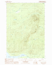
1985 Map of Mooseleuk Mtn
USGS Topo · Published 1986About this map
Mooseleuk Mountain and Willard Mountain dominate this mid-1980s landscape in Northern Maine, a region defined by commercial timberlands and specialized backcountry surveying. The topographic detail highlights the industrial footprint of the era through several Gravel Pits and a Shale Pit, utilized to maintain the extensive network of Private Roads that facilitate forestry operations. Water features are central to the geography, from the southern reaches of Munsungan Lake to the secluded Norway Pond and Smith Brook Pond. A Radio Facility and the Norway Bluff Lookout Tower stand as vital communication and fire-watch outposts atop Norway Bluff, looking out over a complex drainage system of brooks and streams including Mooseleuk Stream and Little Hudson Brook.
Find a feature on this map
32 named features on this map. Tap any name to fly to it.
Don’t see what you’re looking for? This feature index may not catch every label — zoom into the map to look around manually.
Map Details
Editions of this 1985 Mooseleuk Mtn Map
This is the sole edition of this map. No revisions or reprints were ever made.
Other maps of this area

1931 · Mooseleuk Lake
USGS Topo · 1:48,000

1932 · Musquacook Lakes
USGS Topo · 1:48,000

1935 · Musquacook Lakes
USGS Topo · 1:62,500

1935 · Mooseleuk Lake
USGS Topo · 1:62,500

1954 · Spider Lake
USGS Topo · 1:62,500

1954 · Millinocket Lake
USGS Topo · 1:62,500

1954 · Presque Isle
USGS Topo · 1:250,000

1958 · Presque Isle
USGS Topo · 1:250,000

1960 · Presque Isle
USGS Topo · 1:250,000

1961 · Spider Lake
USGS Topo · 1:62,500