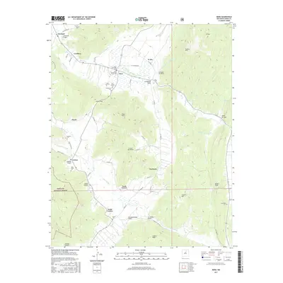
2017 Map of Mora
USGS Topo · Published 2017About this map
Mora lies at the heart of this high-elevation landscape, where the Mora River and its tributaries carve a network of valleys through the El Oro Mountains. This 2017 survey reveals a deeply rooted pattern of settlement, with small communities like Cleveland, Cordillera, North Carmen, and South Carmen following the riverbanks and mountain passes. Genealogists will find an exceptional concentration of family-linked sites, including the Santa Gertrudes Cem, Saint Vrain Cem, and the Mora Presbyterian Church. The transition from the high peaks of Eagle Peak to the sheltered Los Aguatas Valley and La Cebolla Valley illustrates how the physical geography dictated the placement of roads and homesteads. Large tracts of the Santa Fe National Forest border the western edge, protecting the headwaters of the Rito Cebolla and Rito Morphy that sustain these mountain villages.
Find a feature on this map
76 named features on this map. Tap any name to fly to it.
Don’t see what you’re looking for? This feature index may not catch every label — zoom into the map to look around manually.
Map Details
Editions of this 2017 Mora Map
This is the sole edition of this map. No revisions or reprints were ever made.
Other maps of this area

1889 · Las Vegas
USGS Topo · 1:125,000

1891 · Las Vegas
USGS Topo · 1:125,000

1893 · Las Vegas
USGS Topo · 1:125,000

1954 · Santa Fe
USGS Topo · 1:250,000

1954 · Raton
USGS Topo · 1:250,000

1958 · Raton
USGS Topo · 1:250,000

1958 · Santa Fe
USGS Topo · 1:250,000

1963 · Lake Isabel
USGS Topo · 1:24,000

1963 · Rainsville
USGS Topo · 1:24,000
1965 · Rociada
USGS Topo · 1:24,000