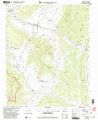
2002 Map of Mora
USGS Topo · Published 2003About this map
The Mora River valley serves as the central artery for this high-altitude landscape, where centuries of land-grant history and spiritual life converge. This 2002 revision shows the community of Mora and surrounding villages like Cleveland, Cordillera, and Ledoux as they sit beneath the towering El Oro Mountains. The map is particularly dense with genealogical markers, documenting numerous small burial grounds and places of worship that define the local heritage, including St Gertrude Cem, St Vrain Cem, and the Sacred Heart Chapel.
Find a feature on this map
72 named features on this map. Tap any name to fly to it.
Don’t see what you’re looking for? This feature index may not catch every label — zoom into the map to look around manually.
Map Details
Editions of this 2002 Mora Map
This is the sole edition of this map. No revisions or reprints were ever made.
Other maps of this area

1889 · Las Vegas
USGS Topo · 1:125,000

1891 · Las Vegas
USGS Topo · 1:125,000

1893 · Las Vegas
USGS Topo · 1:125,000

1954 · Santa Fe
USGS Topo · 1:250,000

1954 · Raton
USGS Topo · 1:250,000

1958 · Raton
USGS Topo · 1:250,000

1958 · Santa Fe
USGS Topo · 1:250,000

1963 · Lake Isabel
USGS Topo · 1:24,000

1963 · Rainsville
USGS Topo · 1:24,000
1965 · Rociada
USGS Topo · 1:24,000