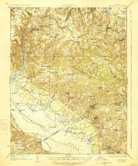
1918 Map of Morattico
USGS Topo · Published 1926About this map
The Rappahannock River defines this coastal Virginia landscape, where a dedicated Steamboat Route connected riverfront communities long before modern bridges spanned the reach. The interior of the Northern Neck is characterized by a network of tidal creeks and millponds, such as Totuskey Creek and Falls Millpond, which supported local industry and agriculture during the early twentieth century. Dozens of small settlements and post offices are scattered throughout the quadrangle, including Haynesville, Village, and Lively.
Find a feature on this map
92 named features on this map. Tap any name to fly to it.
Don’t see what you’re looking for? This feature index may not catch every label — zoom into the map to look around manually.
Map Details
Editions of this 1918 Morattico Map
3 editions found

Other maps of this area

1892 · Piney Point
USGS Topo · 1:62,500

1892 · Montross
USGS Topo · 1:62,500

1894 · Piney Point
USGS Topo · 1:62,500

1894 · Point Lookout
USGS Topo · 1:62,500

1895 · Nomini
USGS Topo · 1:125,000

1895 · Piney Point
USGS Topo · 1:62,500

1895 · Montross
USGS Topo · 1:62,500

1898 · Nomini
USGS Topo · 1:125,000

1898 · St. Marys
USGS Topo · 1:125,000

1901 · Piney Point
USGS Topo · 1:62,500