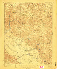
1918 Map of Morattico
USGS Topo · Published 1926About this map
Rappahannock River commerce and rural tidewater life define this 1917 survey of the Northern Neck. The landscape is interconnected by a Steamboat Route serving riverfront points like Sharps and Bowlers Wharf, providing a vital link for local agriculture before the dominance of modern highways. Inland, the map reveals a dense network of country schools and houses of worship, such as the Lonely Oak School and Totuskey Church, which served as the social anchors for dispersed communities like Haynesville and Luttrellville.
Find a feature on this map
94 named features on this map. Tap any name to fly to it.
Don’t see what you’re looking for? This feature index may not catch every label — zoom into the map to look around manually.
Map Details
Editions of this 1918 Morattico Map
3 editions found

Other maps of this area

1892 · Piney Point
USGS Topo · 1:62,500

1892 · Montross
USGS Topo · 1:62,500

1894 · Piney Point
USGS Topo · 1:62,500

1894 · Point Lookout
USGS Topo · 1:62,500

1895 · Nomini
USGS Topo · 1:125,000

1895 · Piney Point
USGS Topo · 1:62,500

1895 · Montross
USGS Topo · 1:62,500

1898 · Nomini
USGS Topo · 1:125,000

1898 · St. Marys
USGS Topo · 1:125,000

1901 · Piney Point
USGS Topo · 1:62,500