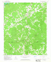
1966 Map of Moravian Falls
USGS Topo · Published 1968About this map
Moravian Falls and the surrounding Brushy Mountains are documented here in the mid-1960s, a period defined by the recent creation of the W Kerr Scott Reservoir and the development of lakeside recreation at Bandits Roost Park. The landscape is characterized by a dense network of country churches, including Walnut Grove Ch and Mt Carmel Ch, which served the scattered settlements of Boomer and Oakwoods. This era shows a transition from traditional mountain life toward more modernized land use, evidenced by the presence of the Oakwoods Country Club and Yellow Jacket Lake. Significant topographical landmarks such as Pores Knob Lookout Tower and Sugarloaf Mtn provide fixed points for navigating the complex terrain of ridges and gaps, while the Yadkin River and Little River drainage basins define the region's hydrology.
Find a feature on this map
54 named features on this map. Tap any name to fly to it.
Don’t see what you’re looking for? This feature index may not catch every label — zoom into the map to look around manually.
Map Details
Editions of this 1966 Moravian Falls Map
This is the sole edition of this map. No revisions or reprints were ever made.
Other maps of this area

1889 · Wilkesboro
USGS Topo · 1:125,000

1891 · Wilkesboro
USGS Topo · 1:125,000

1895 · Hickory
USGS Topo · 1:125,000

1953 · Charlotte
USGS Topo · 1:250,000

1953 · Winston-Salem
USGS Topo · 1:250,000

1954 · Charlotte
USGS Topo · 1:250,000

1955 · Winston-Salem
USGS Topo · 1:250,000

1960 · Charlotte
USGS Topo · 1:250,000

1962 · Winston-Salem
USGS Topo · 1:250,000

1962 · Charlotte
USGS Topo · 1:250,000