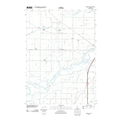
2010 Map of Moreland
USGS Topo · Published 2010About this map
Moreland and its surrounding agricultural communities define this landscape west of the Snake River. The region's history is deeply tied to a sophisticated irrigation network, visible through dozens of named waterways like the Peoples Canal, Aberdeen Springfield Canal, and the Danskin Canal. These man-made features weave between the Snake River and the Blackfoot River, supporting small settlements such as Aiken, Clarkson, and Riverside. This 2010 survey highlights how water management transformed the high desert into a productive corridor. Genealogists will find three significant burial sites: Moreland Cemetery in the north, Thomas Riverside Cemetery centrally located, and Gibson Cemetery in the southeast. Notable landmarks like the Riverton Access Area and the private Russell W Anderson Strip airfield further illustrate the blend of recreational river access and rural aviation in this part of Bingham County.
Find a feature on this map
83 named features on this map. Tap any name to fly to it.
Don’t see what you’re looking for? This feature index may not catch every label — zoom into the map to look around manually.
Map Details
Editions of this 2010 Moreland Map
This is the sole edition of this map. No revisions or reprints were ever made.
Other maps of this area

1940 · Blackfoot
USGS Topo · 1:62,500

1943 · Blackfoot
USGS Topo · 1:62,500

1955 · Baldy Knoll
USGS Topo · 1:24,000

1955 · Rockford
USGS Topo · 1:24,000

1955 · Rose
USGS Topo · 1:24,000

1955 · Pingree
USGS Topo · 1:24,000

1955 · Idaho Falls
USGS Topo · 1:250,000

1958 · Idaho Falls
USGS Topo · 1:250,000
1971 · Fort Hall
USGS Topo · 1:24,000
1971 · Buckskin Basin
USGS Topo · 1:24,000