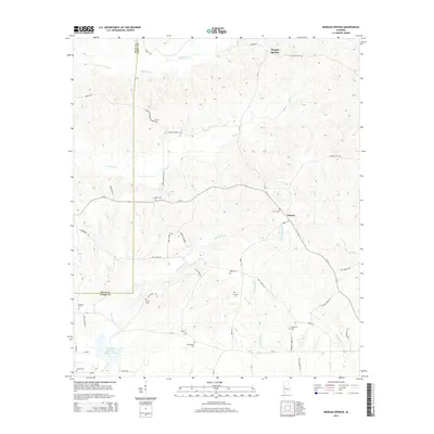
2014 Map of Morgan Springs
USGS Topo · Published 2014About this map
Morgan Springs and Folsom anchor this rural landscape in western Alabama, where the border between Hale Co and Perry Co follows the local topography. This 2014 survey captures a region defined by its creeks and cemeteries, illustrating a long-established pattern of small family and community burial grounds. From Griffin Cem in the north to the Turpin Cem near Curry in the south, these sites are often situated near the headwaters of drainage systems like Polecat Cr and Big Brush Cr. The road network, including the winding Al-14, connects these scattered settlements across the watershed of Bogue Chitto Cr. A man-made intervention in this hydrologic system is visible at Watershed Structure Number Twelve, which manages the flow of Big Prairie Cr as it moves toward the Hale County line.
Find a feature on this map
52 named features on this map. Tap any name to fly to it.
Don’t see what you’re looking for? This feature index may not catch every label — zoom into the map to look around manually.
Map Details
Editions of this 2014 Morgan Springs Map
This is the sole edition of this map. No revisions or reprints were ever made.
Other maps of this area

1953 · Montgomery
USGS Topo · 1:250,000

1956 · Montgomery
USGS Topo · 1:250,000

1957 · Montgomery
USGS Topo · 1:250,000

1979 · Marion North
USGS Topo · 1:24,000

1979 · Scott Station
USGS Topo · 1:24,000

1979 · Morgan Springs
USGS Topo · 1:24,000

1979 · Marion South
USGS Topo · 1:24,000

1979 · Greensboro
USGS Topo · 1:24,000

1980 · Ingram
USGS Topo · 1:24,000
1980 · Newbern
USGS Topo · 1:24,000