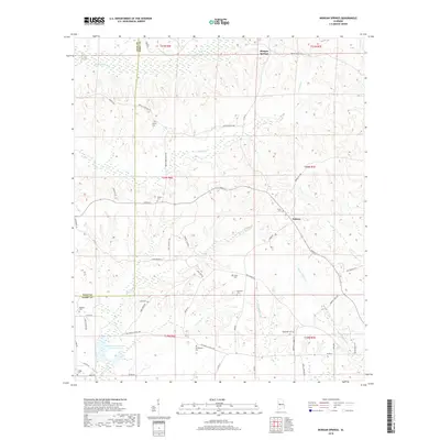
2018 Map of Morgan Springs
USGS Topo · Published 2018About this map
Morgan Springs and Folsom anchor this rural landscape in western Perry County, where the terrain is defined by a dense network of creek drainages including Big Brush Cr, Polecat Cr, and Big Prairie Cr. The settlement pattern is characterized by scattered family homesteads and a remarkable density of small family or church burial grounds. Notable among these are DeYampert Cem, Griffin Cem, and Hopewell Cem, which provide significant points of interest for genealogical research in this portion of the Black Belt region.
Find a feature on this map
59 named features on this map. Tap any name to fly to it.
Don’t see what you’re looking for? This feature index may not catch every label — zoom into the map to look around manually.
Map Details
Editions of this 2018 Morgan Springs Map
This is the sole edition of this map. No revisions or reprints were ever made.
Other maps of this area

1953 · Montgomery
USGS Topo · 1:250,000

1956 · Montgomery
USGS Topo · 1:250,000

1957 · Montgomery
USGS Topo · 1:250,000

1979 · Marion North
USGS Topo · 1:24,000

1979 · Scott Station
USGS Topo · 1:24,000

1979 · Morgan Springs
USGS Topo · 1:24,000

1979 · Marion South
USGS Topo · 1:24,000

1979 · Greensboro
USGS Topo · 1:24,000

1980 · Ingram
USGS Topo · 1:24,000
1980 · Newbern
USGS Topo · 1:24,000