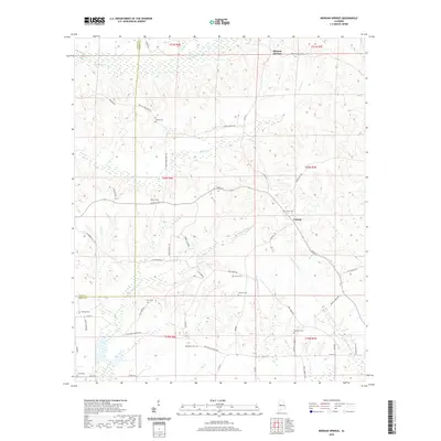
2020 Map of Morgan Springs
USGS Topo · Published 2020About this map
Morgan Springs and the small community of Folsom anchor this rural landscape in western Alabama, where the terrain is defined by a dense network of meandering waterways. The drainage patterns of Bogue Chitto Cr, Big Prairie Cr, and Polecat Cr intersect a complex grid of country roads, including Oak Grove Church Rd and Goat Man Rd. The map is particularly rich for genealogical research, documenting numerous family and community burial grounds such as DeYampert Cem, Griffin Cem, and Hopewell Cem that dot the countryside. This 2020 edition reveals a landscape of enduring rural character, where small settlements and cemeteries are connected by a web of local routes like Boots Northcutt Rd and Mule Barn Rd, preserving the location of long-established landmarks amidst the creek bottoms and rising ridges.
Find a feature on this map
58 named features on this map. Tap any name to fly to it.
Don’t see what you’re looking for? This feature index may not catch every label — zoom into the map to look around manually.
Map Details
Editions of this 2020 Morgan Springs Map
This is the sole edition of this map. No revisions or reprints were ever made.
Other maps of this area

1953 · Montgomery
USGS Topo · 1:250,000

1956 · Montgomery
USGS Topo · 1:250,000

1957 · Montgomery
USGS Topo · 1:250,000

1979 · Marion North
USGS Topo · 1:24,000

1979 · Scott Station
USGS Topo · 1:24,000

1979 · Morgan Springs
USGS Topo · 1:24,000

1979 · Marion South
USGS Topo · 1:24,000

1979 · Greensboro
USGS Topo · 1:24,000

1980 · Ingram
USGS Topo · 1:24,000
1980 · Newbern
USGS Topo · 1:24,000