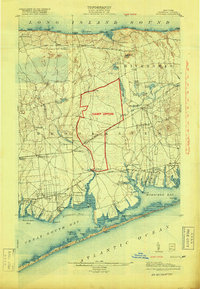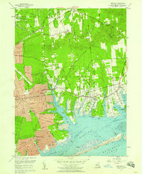
1957 Map of Moriches
USGS Topo · Published 1958About this map
Brookhaven National Laboratory and the surrounding U S Reservation occupy the northwestern corner of this mid-century Long Island landscape. To the south, the post-war suburban development of Shirley, Mastic, and Mastic Beach is visible in the dense grid of residential streets, contrasting with the more traditional settlement patterns of Moriches, Center Moriches, and East Moriches along the Montauk Highway. This era represents a period of significant growth before the completion of the Long Island Expressway, which appears here in a preliminary state. The coastline is defined by complex tidal estuaries including the Forge River, Old Neck Creek, and Terrell River, which lead into the sheltered waters of Moriches Bay. Numerous family-named landmarks like Floyd Cemetery and Hawkins Cemetery provide vital links for local historians, while the barrier beach of Fire Island Beach and the Moriches Inlet mark the transition to the open sea.
Find a feature on this map
94 named features on this map. Tap any name to fly to it.
Don’t see what you’re looking for? This feature index may not catch every label — zoom into the map to look around manually.
Map Details
Editions of this 1957 Moriches Map
This is the sole edition of this map. No revisions or reprints were ever made.
Historical Maps of Brookhaven Through Time
8 maps found