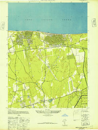
1947 Map of Middle Island
USGS Topo · Published 1947About this map
The northern coast of Brookhaven along the Long Island Sound is defined by high bluffs and a series of historic landings, including Woodhull Landing and Rocky Point Landing. This 1947 survey, based on wartime aerial photography, shows the burgeoning residential patterns of Sound Beach and Miller Place as they began to expand from the coast toward the Port Jefferson Branch railroad line. Further inland, the landscape is dominated by the sprawling RCA Radio Station and its distinctive circular array of towers, a critical hub for international communications during this period.
Find a feature on this map
28 named features on this map. Tap any name to fly to it.
Don’t see what you’re looking for? This feature index may not catch every label — zoom into the map to look around manually.
Map Details
Editions of this 1947 Middle Island Map
2 editions found
Other maps of this area

1891 · Bridgeport
USGS Topo · 1:62,500

1893 · Bridgeport
USGS Topo · 1:62,500

1902 · Setauket
USGS Topo · 1:62,500

1904 · Setauket
USGS Topo · 1:62,500

1904 · Islip
USGS Topo · 1:125,000

1904 · Moriches
USGS Topo · 1:62,500

1919 · Setauket
USGS Topo · 1:62,500

1920 · Bridgeport
USGS Topo · 1:62,500

1942 · Islip
USGS Topo · 1:125,000

1947 · Bellport
USGS Topo · 1:24,000