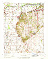
1963 Map of Morley
USGS Topo · Published 1968About this map
The Headwater Diversion Channel and Dutchtown Ditch dominate the northern landscape of Scott County, illustrating the massive hydrological engineering required to manage the Mississippi River drainage system. This 1963 survey shows the convergence of the St Louis-San Francisco, Missouri Pacific, and Southwestern railroads, which facilitated the development of rail hubs like Chaffee, Illmo, and Scott City. Centered around the rugged high ground of Cox Hill and Bell Hill, the map reveals a network of small agricultural settlements and rural institutions, including Guardian Angel Ch and New Hamburg. Genealogists can locate several burial grounds such as St Denis Cem and Moore Cem, while industrial sites like the Gravel Pit near Kelso point to the local extractive economy of the mid-20th century.
Find a feature on this map
66 named features on this map. Tap any name to fly to it.
Don’t see what you’re looking for? This feature index may not catch every label — zoom into the map to look around manually.
Map Details
Editions of this 1963 Morley Map
This is the sole edition of this map. No revisions or reprints were ever made.
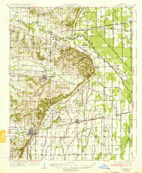
Other maps of this area

1920 · Jonesboro
USGS Topo · 1:62,500

1922 · Cape Girardeau
USGS Topo · 1:62,500

1923 · Jonesboro
USGS Topo · 1:62,500

1924 · Cape Girardeau
USGS Topo · 1:62,500

1931 · Sikeston
USGS Topo · 1:62,500

1933 · Marble Hill
USGS Topo · 1:62,500

1934 · Thebes
USGS Topo · 1:62,500

1934 · Morley
USGS Topo · 1:62,500
1934 · Bloomfield
USGS Topo · 1:62,500

1934 · Sikeston
USGS Topo · 1:62,500