
Loading...
Loading map...1934 Map of Sikeston
USGS Topo · Published 1934About this map
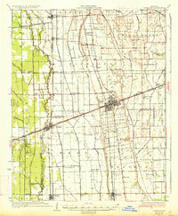
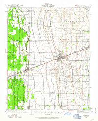
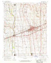
Sikeston serves as the central hub of this 1934 survey, anchored by the intersection of Highway No 61 and Highway No 60. The landscape reveals a highly engineered agricultural region, defined by an extensive network of drainage features such as Ditch No 3 and Ditch No 37 that reclaimed the lowlands surrounding Sandy Woods and Long Prairie. The rail infrastructure is equally dense, with the St Louis San Francisco RR, St Louis Southwestern RR, and Missouri Pacific RR all converging in the area to support the shipping of local harvests.
Find a feature on this map
68 named features on this map. Tap any name to fly to it.
Don’t see what you’re looking for? This feature index may not catch every label — zoom into the map to look around manually.
Map Details
Date Portrayed1934
Date Published1934
PublisherU.S. Geological Survey
Map TypeTopographic
Scale1:62,500
Physical Dimensions16.61 x 20.29 inches
Editions of this 1934 Sikeston Map
2 editions found
Historical Maps of Sikeston Through Time
5 maps found

Featured Locations
Source Details
SourceU.S. Geological Survey
CopyrightPublic Domain